Anchorage Snow Event: December 28-29, 1955
On December 28 and 29, 1955, Anchorage, Alaska, endured the greatest snow event since record-keeping began. A remarkable 29 inches fell on those two calendar days. When looking at a four day period, 35.5 inches fell. This discussion focuses on the 2-day period where 29 inches fell since it represents a clearly definable, discrete event in the climate record.
The Datasets
This analysis utilizes several National Oceanographic and Atmospheric Administration (NOAA) databases that are available to the general public. They include: 1) the National Climate Data Center's (NCDC) GHCN summary of daily conditions, 2) the Earth System Research Laboratory (ESRL) reanalysis data, 3) the NCDC DS3505 hourly observation database, and finally, we use clippings from two Anchorage newspapers.
The Surface Setup
December 1955 was fairly cold in Anchorage with a typical amount of snow through the first 27 days of the month. The average high temperature was 16°F and the average low temperature was 0°F. Through December 27, 10.1 inches of snow fell, which is slightly lower than normally occurs during that time period. However, a brief pattern change was about to take place ('brief,' because the first half of the following month was extremely cold and dry).
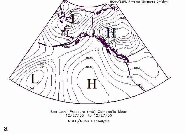
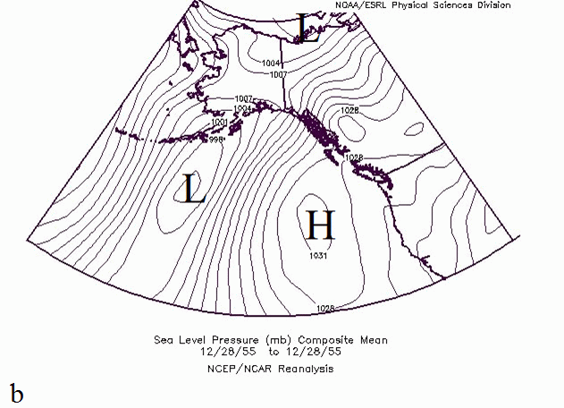
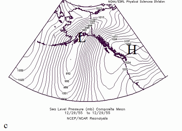
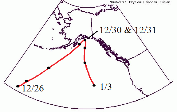
A substantial high pressure system moved into the Bering Sea during late December as an existing high pressure center strengthened in British Columbia. This resulted in a massive trough of low pressure between the two high pressure centers. Figure 1 shows the ESRL Reanalysis surface pressure pattern and Figure 2 shows the track of the low pressure center.
The Upper Air Setup
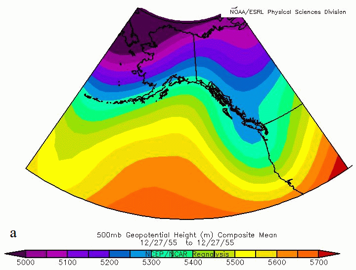
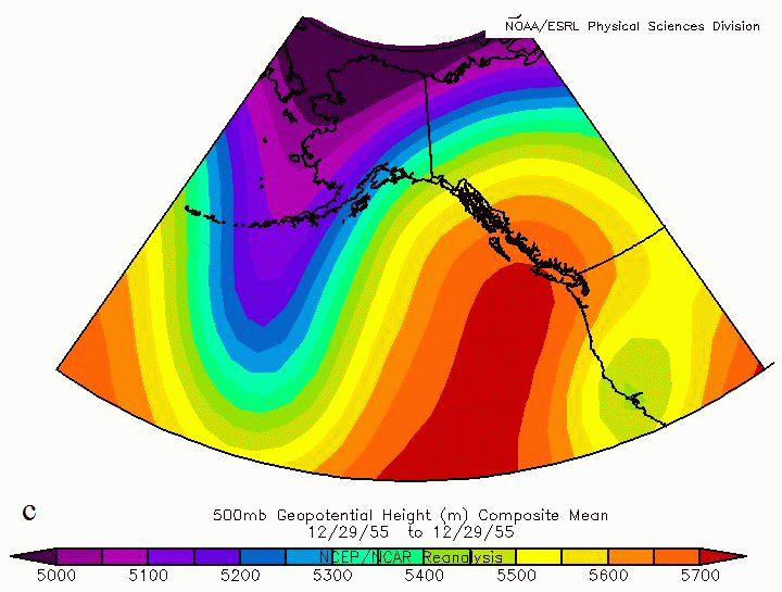
A look at the ESRL 500 mb geopotential height map shows a deep H5 trough of low pressure centered over the high Arctic with a negatively tilted axis developing and extending past the central Aleutian Islands. This type of upper air pattern is not uncommon in Alaska during the winter but the magnitude is somewhat atypical. Figure 3 shows the geopotential heights at the 500mb pressure level. In general, lower heights represent upper level low pressure and high heights represent upper level high pressure. Since winds are geostrophic at this level, the winds move parallel to the isolines.

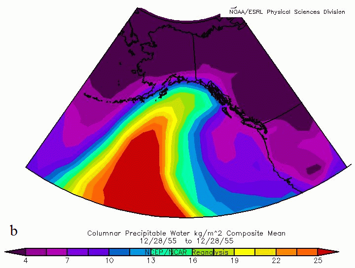
The upper level pressure and wind pattern formed a classical pineapple express that took aim on southern Alaska. A long southerly fetch of moisture-laden air traveled along the 150th meridian originating near the Hawaiian Islands. The upstream focus of this plume of moisture extended from as far west as Cook Inlet and eastward to include all of Prince William Sound and much of the Panhandle. Figure 4 shows the ESRL Reanalysis estimate of precipitable water.


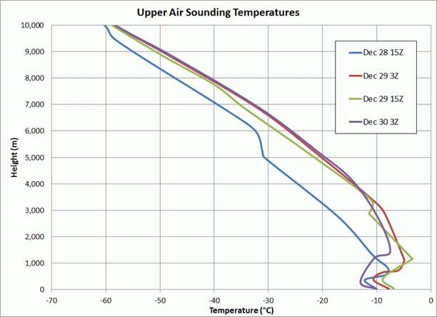
Weather balloon soundings have been recorded twice daily at the Anchorage International Airport ever since the program was initiated in 1948. In 1955, the balloons were launched at 6 a.m. and 6 p.m. local Standard time (3Z and 15Z). Figure 5 shows the temperature profile for four balloon soundings during the heavy precipitation event. There is a noticeable warm layer between 400m and 1000m on several of the soundings. The wind component at the 700mb and 500mb level (not shown) varied between south and southwest on all soundings. Unfortunately there is no data for moisture (dew point, mixing ratio, vapor pressure, etc.) so we cannot directly compute precipitable water, vorticity, or many other useful variables.
The Hourly Observations
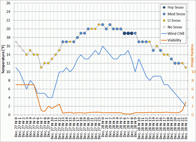
There were 40 consecutive hours between 7 a.m. on December 28 and 10 p.m. on December 29 where snow was observed and the visibility was 2.5 miles or less. A few hours either side of those 40 hours saw light snow with visibilities between 7 and 10 miles. It is reasonable to assume that at least 27 of the 29 inches recorded on those two days fell during the 40-hour period. Figure 6 shows the temperature, snow intensity, wind chill, and visibility for the two calendar days. The wind during the entire two-day period originated from the north and northeast at speeds between 7 and 10 miles per hour (mph). This represents a classic down-Inlet, cold air advection flow that frequently causes enhanced meso-scale lift.
The daily summary for Anchorage International Airport is shown in Table 1. Both days recorded high and low temperature values that are typical for the date. However, the precipitation and snow values are extremely high.

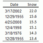
The 13.4 inches on December 28 represents the 6th largest calendar day snow in Anchorage and the 15.6 inches on December 29 represents the 2nd largest calendar day snowfall. Table 2 shows the largest calendar day snow observations for Anchorage.
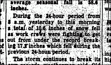
A review of the Anchorage Times and the Anchorage Daily News provides a little more insight into the conditions within the city and the region. In addition to stories about people being stuck, busses not moving, stores closed, and the constant sound of snow plows, there is a reference to 24-hour snowfall measurements. Specifically, they mention that 17.2 inches fell between 8 a.m. on December 29 and 8 a.m. on December 30th (see Figure 7). While this value does not eclipse the March 2002 event, it is larger than the currently listed calendar day total.
Regional Impact
Unlike the March 2002 snow event in Anchorage, the December 1955 storm produced record rain and snow over an area from the Susitna River basin to the Panhandle. Story headlines from the Anchorage Times regarding the impacts to Cordova and to Yakutat are shown in Figure 8.

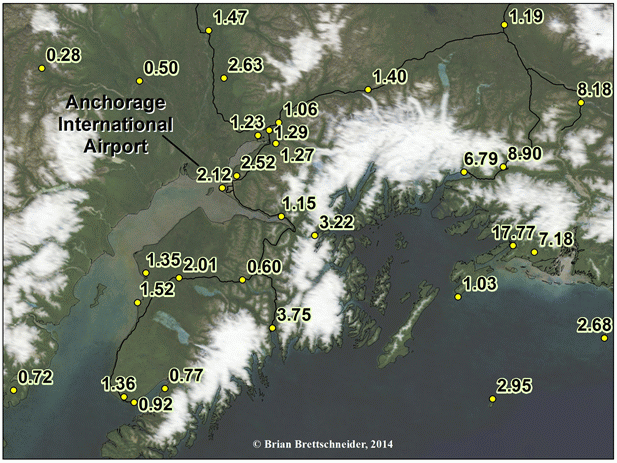
Areas that normally receive heavy precipitation, like Valdez, Cordova, and Yakutat, lived up to their reputations. Both Cordova and Valdez recorded their wettest calendar day in their respective climate histories. Cordova observed 17.77 inches of mostly rain during a 2-day period. The 14.13 inches on December 29th was a single-day record for Alaska at the time. Thompson Pass, which by some measures is the snowiest location in Alaska, recorded their greatest single day snowfall in the 25-year record of that station. An amazing 62.0 inches was observed on December 29 1955 to follow the 26.4 inches that fell on December 28th. On December 30th, an additional 58.6 inches fell bringing the three-day total to 147 inches. Figure 9 shows the 2-day precipitation for stations surrounding Prince William Sound and Figure 10 shows the 2-day snow amounts for those same stations.

Conclusion
A majority of heavy snow events in Anchorage occur when a large plume of moisture follows a low pressure into western Prince William Sound. This setup allows for northerly winds that advect cold air down Cook Inlet which provides a meso-scale forcing mechanism to enhance the synoptic-scale forcing. In addition, the flow minimizes the downsloping that is typical with a more easterly component to the wind; therefore, the moisture streaming from the Tropics flows unimpeded over the Chugach Mountains. Based on all available information, the December 1955 storm appeared to follow this well-established pattern that has been repeated many times since - except on a much larger scale. Given the synoptic and meso-scale features, I suspect that were this storm to materialize in 2014, it would be well forecasted several days in advance.
The storm of late December 1955 is one for the record books. Not only was an incredibly large amount of snow and rain observed, but the spatial extent was larger than other storms with similar synoptics. The Unites States Weather Bureau collected excellent information that enabled this post-storm discussion nearly 60 years after the fact. Many thanks should be given to the numerous people who collected this, and all other climate data.

Maps and narrative by Brian Brettschneider, © 2014
No comments:
Post a Comment